30×30 Toolkit
Introduction
What is this about? This document provides the context, guidance, and tools to support data contribution of conserved lands in California. These lands are to be considered for the state’s 30×30 initiative to conserve 30% of California’s land and waters by 2030.
Who is this for? This document, and the overall toolkit of which it is a part, are for organizations that own or manage lands or conservation easements, who wish to update and improve how those lands are represented in the 30×30 initiative. Note that the toolkit does not cover the conservation of marine ecosystems that are part of a separate element in 30×30.
What is 30×30?
In October 2020, Governor Newsom signed his Nature Based Solutions Executive Order N-82-20, elevating the role of natural and working lands in the fight against climate change and advancing biodiversity conservation as an administration priority. As part of this Executive Order, California committed to the goal of conserving 30 percent of our lands and coastal waters by 2030.
Find out much more about the overall initiative at www.californianature.ca.gov.
For the purposes of this toolkit, the most important aspect of 30×30 is that lands that meet certain management criteria count toward the 30% goal as “conserved.” These lands qualify as GAP status 1 or 2 under the national GAP code system maintained by the US Geological Survey and described in detail in this toolkit.
There are other ways to contribute to the overall 30×30 goals, but this toolkit is focused on gathering information about lands conserved for biodiversity.
Protected Lands and 30×30
The state of California has multiple data sets that feed into 30×30. At the outset, two key geospatial databases are used to define, track, and share information about the extensive and unique lands protected by hundreds of federal, state, local, and nonprofit agencies across California. These databases, CPAD and CCED, have been augmented with GAP Codes in order to portray the various levels of protection of natural landscapes and biodiversity on them.
CPAD
The California Protected Areas Database (CPAD) is an inventory of lands protected by fee title, with details on each property:
- Location and extent
- Name of the park or open space
- Owning agency
- Managing agency
- Level of public access (no access, restricted, open)
CCED
The California Conservation Easement Database (CCED) is an inventory of lands protected by an easement, with details on each easement:
- Location and extent
- Managing agency
- Level of public access (no access, restricted, open)
GAP Codes
The GAP Status Code is used to measure the level of protection of biodiversity on a landscape. The intent to manage for biodiversity is evaluated by the land’s level of: Protection, Management, Physical Alteration, Main use(s).
Why are they used in 30×30? GAP codes represent one of the few broadly accepted and applied measures of biodiversity protection. The codes, which include four classifications, were developed as part of the U.S. Geological Survey’s Gap Analysis Project (GAP). The GAP code system is used in the Protected Areas Database of the United States (PAD-US), published by USGS GAP, and as such it represents a de facto standard and has broad coverage on federal and state lands.
Are GAP codes a perfect system? Like any classification system, GAP codes are imperfect. Many lands cannot be easily classified, and lands of similar type may be managed for different purposes.
What do GAP codes actually measure? It is important to recognize that GAP Codes are a measure of biodiversity protection — how the natural habitats on a piece of land are managed (are biodiversity and natural processes the priority?) and how durable those protections are (will they stay in place in the future?). GAP Codes are not a measure of actual species diversity or richness, nor are they a measure of a land’s ecological importance.
Why “natural land cover”? At the base of GAP status codes is the assumption that “retention of natural land cover is of prime importance to maintaining biodiversity” (USGS, 2021).
What counts as “natural land cover”? The USGS defines “natural land cover” as areas not maintained in a human-induced, unnatural state. In such unnatural states, the plant communities are either missing or cultivated exotic-dominated. Natural land covers allow for the succession of plant communities, without arresting that natural progression. While it is key that a natural land cover is not being intentionally altered by human activities, it is allowed for past alterations to be evident. (USGS, 2021)
Do GAP codes measure Other Effective Area-Based Conservation Measures (OECMs)? The key GAP code qualifications for types 1 and 2 apply to a fairly narrow set of protections most aligned with more stringent protections of wilderness lands. GAP codes do not measure the many Other Effective Area-Based Conservation Measures (OECM). As described in the state’s Pathways to 30×30 document, OECMs are not tracked via GAP codes and include things like small native plant gardens, hedgerows, riparian buffers, urban tree canopy, and organic farms. It remains to be seen how OECMs are tracked as part of 30×30, and this toolkit does not address them.
How to Contribute Your Data to 30×30
Local land owning agencies know their lands best! In an effort to support the 30×30 initiative, we are requesting you provide us with two key things:
- Ensure our inventory of your lands is correct
- Report the GAP Codes most appropriate for each of your lands
We are accepting feedback on all 3 inputs: CPAD, CCED, and each land’s associated GAP Codes.
When are my updates due?
Please use the materials provided to submit your input. GreenInfo Network will aim to include as many updates as possible in the 2023a release of CPAD/CCED (anticipated June 2023). To have your updates considered for the 2023a release, please submit your information by May 29, 2023. While we will strive to include all updates, some may not be reflected until 2023b (scheduled for December 2023).
CNRA anticipates the next update to 30×30 data will use the CPAD/CCED 2023b release. To ensure your input is included in the next 30×30 data update, it must be submitted to GreenInfo by October 31, 2023.
Upcoming Events
No Planned Events
Resources
In the following sections you will find webinars and slide decks about the 30×30 Toolkit, as well as links to resources on 30×30, CPAD & CCED, and GAP Codes.
Webinars + Slide Decks
Webinars
- Bay Area Greenprint and 30×30 here
- CPAD, CCED, Conservation Lands Network, and 30×30 here
- CCLT & GreenInfo 30X30 Webinar here
- Friends of Harbors Beaches and Parks here in English and Español (we were Pathway 10. Spanish translation available for audio, slides, and materials)
Slide Decks
30×30 Resources
CPAD & CCED
Learn more about the protected lands tracked in CPAD and CCED
GAP Code Resources
Start my Review
CPAD and CCED are spatial databases that track protected lands (fee ownership and conservation easement) across the state of California. These two datasets feed into the 30×30 effort. While the full state databases are available, we have created files grouped by the agency/organization responsible for the management of the land.
The following sections will guide you through the process of: downloading the toolkit packet, selecting the appropriate method of review, selecting which files to use in your review, step-by-step methods for conducting a data review, and how to submit your completed packet.
Download my Toolkit
To start, you will download the toolkit for your agency. Here’s how:
- Go to 30×30 Toolkit Downloads
- Navigate the list to locate your agency’s file
- Agency names are not abbreviated
- City/County data is listed with the city/county name first. Example: “Berkeley, City of”
- Download the file for your agency to the computer you will use for the review
- Files size: The size of the file will depend on the complexity and number of lands managed by your agency. Most files are well under 1 MB.
- Unzip the files to the location you intend to store them while conducting your review.
Determine my Methods
Review Methods
We provide multiple options for reviewing your lands. These options are intended to allow agencies/organizations to select the technical approach that best fits their technical comfort level, ability, and time constraints.
GIS
For groups with GIS capacity, we offer shapefiles for both fee and easement lands (as they are currently represented in CPAD and CCED). These files can be viewed in a variety of software programs such as ArcGIS Pro/Map and QGIS.
Agencies that elect to use GIS to review their lands can return modified shapefiles reflecting changes to be incorporated into CPAD and CCED. Modifications can include revised shapes, revised attributes, new lands, and flags for lands to be removed.
TABULAR + MAPS
For those that prefer a less technical approach, we offer the option to review tables that list the parks/properties (fee and easement) managed by your agency/organization with key information about name, ownership, public access, and acreage.
The information provided in the tables is the same as that in the GIS shapefiles, apart from the lack of geography. To provide the spatial element, maps can be provided in one of 3 ways:
- Links to review a property via MapCollaborator
- PDF maps with each park/property shown over satellite imagery with parcel boundaries (where available)
- KML files to be opened in Google Earth
Those wishing to have PDF or KML files need to contact GreenInfo staff to request a file transfer. These files are provided apart from the initial toolkit download to avoid unnecessary transfer and download of large files.
GAP Code Assignment Methods
We offer two methods of assigning GAP Status to your lands. Determine which of the two methods – singular assignment or detailed assignment – is the most appropriate for each of your properties:
SINGULAR ASSIGNMENT
If at least 95% of a park/property has the same level of protection and management, it can be assigned a single GAP code. For CPAD data users, Singular Assignment assigns GAP codes at the CPAD Super Unit geometry level. CPAD Data Structure.
DETAILED ASSIGNMENT
If different areas of a park/property have different levels of protection, management, or use, it is best to assign multiple GAP codes. Multiple GAP codes can only be entered at the CPAD Holding geometry level using the Detailed Assignment method. This method allows for different percentages of a holding to be assigned to different GAP codes. CPAD Data Structure.
NOTES
The “Detailed Assignment” method still allows for an entire holding to be assigned to a single GAP code by giving the option to assign all 100% of the holding to one GAP code.
All easement data (in CCED) is reported with the Detailed Assignment method. You will still be able to assign single codes when it is most appropriate for your conservation easement.
Select my Working Files
We offer multiple file types to agencies for the data review, based on the chosen method for review and gap assignment. Agencies can use the following form to determine the correct set of working files to use for reviewing lands and assigning GAP codes. Begin your process by:
- Using the Data Use Form below.
- Selecting the appropriate files from your downloaded folder; these will be your working files.
- Making a copy of your working files into a Working Files folder.
Data Use Form
What is in my Working Files?
All the lands in the files provided to you are lands that your agency manages. If you own a property that is managed by another agency it is reflected in their toolkit. The lands managed by your agency are detailed in a total of three files:
- CPAD SingularAssignment file: contains the whole park/property.
- CPAD DetailedAssignment file: contains the individual parcels each park/property is made up of.
- CCED file: contains a mix of single record easements and individual parcels due to data limitations.
SHAPEFILES (skip if not applicable)
If you selected Singular Assignment for your lands in CPAD, and if your agency has lands in CCED, your working files are:
- {YourAgencyName}_CPAD_2022b_SingularAssignment.shp
- {YourAgencyName}_CCED_2022b.shp
If you selected Detailed Assignment for your lands in CPAD, and if your agency has lands in CCED, your working files are:
- {YourAgencyName}_CPAD_2022b_DetailedAssignment.shp
- {YourAgencyName}_CCED_2022b.shp
TABLES (skip if not applicable)
If you selected Singular Assignment for your lands in CPAD, and if your agency has lands in CCED, your working files are:
- {YourAgencyName}_CPAD_2022b_SingularAssignment.xlsx
- {YourAgencyName}_CCED_2022b.xlsx
If you selected Detailed Assignment for your lands in CPAD, and if your agency has lands in CCED, your working files are:
- {YourAgencyName}_CPAD_2022b_DetailedAssignment.xlsx
- {YourAgencyName}_CCED_2022b.xlsx
The tables provide links to view each of your lands in our MapCollaborator platform. You can also submit edits to the shape/boundary of your lands through MapCollaborator. If you have instead chosen to work alongside PDF maps, those will be provided to your agency upon request. Email a request for maps to cpad@calands.org
Shapefile Field Definitions
Table 1: Field Descriptions for CPAD_2022b_SuperUnit.shp
| Field Name | Field Description | Field Editing |
| SUID_NMA | Unique ID for the SuperUnit. | DO NOT EDIT |
| PARK_NAME | Name of the SuperUnit (Park / Property). | Edits allowed |
| ACCESS_TYP | Type of access allowed to the general public. | Edits allowed |
| MNG_AGNCY | Official name of the managing agency. | Edits allowed |
| YR_EST | Year the SuperUnit was established. | Edits allowed |
| ACRES | SuperUnit acres. | Edits allowed |
| GAP_code | Your agency’s GAP Status assignment for the SuperUnit. | INPUT REQUIRED |
| Notes | Your agency’s notes. | Input desirable |
Table 2: Field Descriptions for CPAD_2022b_Holdings.shp
| Field Name | Field Description | Field Editing |
| HOLDING_ID | Unique ID for the Holding. | DO NOT EDIT |
| SUID_NMA | Unique ID for the Superunit that the holding belongs to. | Edits allowed |
| UNIT_NAME | Name of the Holding. | Edits allowed |
| ACCESS_TYP | Type of access allowed to the general public. | Edits allowed |
| AGNCY_NAME | Official name of the owning agency. | Edits allowed |
| MNG_AGNCY | Official name of the managing agency (in this case, your agency). | Edits allowed |
| YR_PROTECT | Year the holding was protected (acquired). | Edits allowed |
| ACRES | Holding acres. | Edits allowed |
| GAP1_% | Percent of the holding acres that can be assigned to GAP code 1. | INPUT REQUIRED |
| GAP2_% | Percent of the holding acres that can be assigned to GAP code 2. | INPUT REQUIRED |
| GAP3_% | Percent of the holding acres that can be assigned to GAP code 3. | INPUT REQUIRED |
| GAP4_% | Percent of the holding acres that can be assigned to GAP code 4. | INPUT REQUIRED |
| Notes | Your agency’s notes. | Input desirable |
Table 3: Field Descriptions for CCED_2022b.shp
| Field Name | Field Description | Field Editing |
| e_hold_id | Unique ID for the conservation easement holding. | DO NOT EDIT |
| sitename | Name of the conservation easement. | Edits allowed |
| esmthldr | Manager of the conservation easement. | Edits allowed |
| pubaccess | Type of access allowed to the general public. | Edits allowed |
| year_est | Year the easement was established. | Edits allowed |
| gis_acres | Easement acres. | Edits allowed |
| GAP1_% | Percent of the holding acres that can be assigned to GAP code 1. | INPUT REQUIRED |
| GAP2_% | Percent of the holding acres that can be assigned to GAP code 2. | INPUT REQUIRED |
| GAP3_% | Percent of the holding acres that can be assigned to GAP code 3. | INPUT REQUIRED |
| GAP4_% | Percent of the holding acres that can be assigned to GAP code 4. | INPUT REQUIRED |
| Notes | Your agency’s notes. | Input desirable |
Review and Revise my Lands
Once you have selected your working files, we need to ensure we have the correct lands for your agency. This review is intended to capture:
- Lands you own/manage but are not in the database
- Lands we have assigned to your agency but you do not own/manage
- Ensure we have the correct property location and size for your lands
- Ensure we have the correct name for each property
- Confirm the level of public access to the land
To better understand what lands get included in CPAD and CCED, please reference What gets included in CPAD and CCED in the FAQ.
Begin Review and Revision
For each of your agency’s lands in your working file, please check if there are:
- Boundary changes
- Name changes
- Manager (your agency) or owner changes
- Level of access changes
- Open = open to the public for agency-designated use(s)
- Restricted = limited (such as by permit, season, etc)
- No Public Access = No public access of the property is permitted
- Missing lands (that you manage)
- Flag any properties that should be deleted
Making Revisions – Shapefiles
You are encouraged to make all revisions directly in your working shapefile. This includes all revisions to attributes and feature geometry.
Making Revisions – Tables
Revisions to attributes (Name, Manager, Owner, Level of Access)
- All revisions to attributes can be made in the columns under the “Any Revisions?” section of your table.
Revisions to geography/shape/boundaries
- Submit a boundary edit using MapCollaborator, or
- Submit a boundary edit using the PDF maps you were provided
Each of these methods is detailed in the next two sections.
Submitting a Boundary Edit with MapCollaborator
Please follow these directions:
In your table file, for the park/property that needs boundary revisions:
- Indicate in the “Notes” column that you are making a boundary edit submission via MapCollaborator.
- Click on the link in the “View Shape” column – it will take you to view the SuperUnit you are reviewing, or the SuperUnit that your Holding belongs to.
Please be aware that MapCollaborator does not have your park/property boundaries at the Holdings level. You are linked to the boundaries of the SuperUnit that your holding belongs to. At this point, you may use MapCollaborator to draw a shape of the new boundary or to make edits to the overall SuperUnit boundaries. Here is how:
If you want to make edits to the overall SuperUnit boundaries:
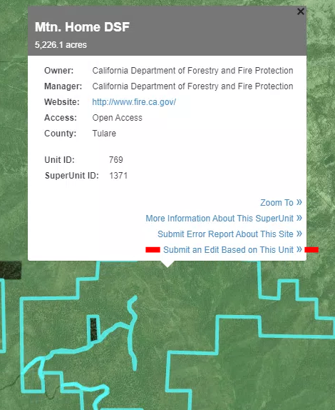
Step 1: Click on the SuperUnit. A box with information will appear (Figure 2). Click on the last option – “Submit an Edit Based on This Unit”.
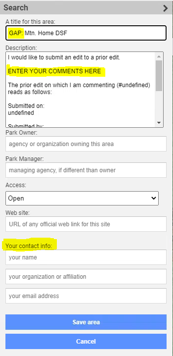
Step 2: An editing form will open on the left of your screen (Figure 3). Please enter the word “GAP” at the beginning of your title, then enter any comments, the owner and manager of the land, access level, and your contact info. Finish by clicking “Save area”.
If you want to draw specific boundaries:
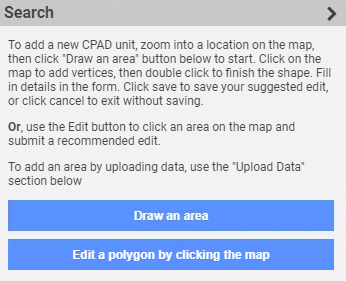
Step 1: Click on the SuperUnit. A box with information will appear (Figure 2). Click on the last option – “Submit an Edit Based on This Unit”, then go to the form that opens on the left (Figure 3), and click cancel.
Step 2: Click “Draw an area” on the left (Figure 4). Proceed to drawing the shape you want to submit, and using the editing form the left of your screen enter details. Please enter the word “GAP” at the beginning of your title, then enter comments, the owner and manager of the land, access level, and your contact info. Finish by clicking “Save area”.
Submitting a Boundary Edit with PDF Maps
If you are working with Tabular data and viewing the spatial aspect of your park/property on PDF maps, you may submit those PDF maps back with edits drawn on them. Edits can be drawn either by hand or with a computer program. You may also submit notes for each of these boundary / shape edits.
Return your Data
Once you have completed your revisions, please send your data back to us via cpad@calands.org. We will update your lands in CPAD and CCED, and we will also update your toolkit files to reflect these changes. We will notify you via email to re-download your 30×30 toolkit before you begin GAP code assignment.
If you have questions about any part of this entire process, please do not hesitate to reach out to us at cpad@calands.org. We look forward to providing customized support.
Assign GAP Status to my Lands
The following sections provide an overview of GAP codes, tools for determining the GAP code for your land, and detailed instructions on entering GAP codes for your lands in your working files.
Before assigning GAP codes to your protected lands, please wait to be notified to re-download the toolkit after submitting your revisions to us from the previous step.
Overview of GAP Codes
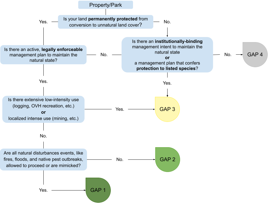
GAP status codes serve as a metric that reflects the long-term management intent (USGS 2020, Prior-McGee 1998) for the biodiversity of the land. The codes were developed by USGS as a part of the Gap Analysis Project. There are four codes, defined as follows (source):
- Status 1: An area having permanent protection from conversion of natural land cover and a mandated management plan in operation to maintain a natural state within which disturbance events (of natural type, frequency, intensity, and legacy) are allowed to proceed without interference or are mimicked through management.
- Status 2: An area having permanent protection from conversion of natural land cover and a mandated management plan in operation to maintain a primarily natural state, but which may receive uses or management practices that degrade the quality of existing natural communities, including suppression of natural disturbance (for example, wildland fire or native insect outbreaks).
- Status 3: An area having permanent protection from conversion of natural land cover for the majority of the area, but subject to extractive uses of either a broad, low-intensity type (for example, logging, OHV recreation) or localized intense type (for example, mining). It also confers protection to federally listed endangered and threatened species throughout the area.
- Status 4: There are no known public or private institutional mandates or legally recognized easements or deed restrictions held by the managing entity to prevent conversion of natural habitat types to anthropogenic habitat types. The area generally allows conversion to unnatural land cover throughout or management intent is unknown.
There are three key elements that help to determine GAP status:
- The spatial extent of permanent protection of natural land cover from conversion to unnatural land cover.
- A legally enforceable or institutionally binding management plan for maintaining and protecting all natural land cover.
- The type and degree of disturbances to the natural community, such as the level of suppression of natural disturbances and the presence of extractive processes or other human-focused uses.
| GAP Status code | Examples |
|---|---|
| 1 |
|
| 2 |
|
| 3 |
|
| 4 |
|
Determine my GAP codes
We have developed two approaches to help assign a GAP Code. The first uses the standard GAP criteria (protection, management) and is phrased as questions. The second is an option to start with the type of land/property/park and answer questions about its use and management.
Assign GAP Codes – Shapefiles
Before you begin assigning GAP codes, please make sure to review the “Determine my Methods” tab under the “Start my Review” section. Once you understand each GAP code assignment method, please proceed with this section. For each property, please choose only one GAP code assignment method (singular or detailed). If some of your properties can be assigned using the singular assignment, please feel free to use that method for those properties. If the rest of your properties must be assigned using the detailed assignment method, please use that method to assign GAP codes for those properties.
If your working file is CPAD_2022b_SingularAssignment.shp:
- Determine the GAP Status for your park/property.
- Use the `GAP_code` field to assign the GAP Status code to your park/property. Input a value of 1, 2, 3, or 4 for GAP Status codes 1, 2, 3, or 4.
If your working file is CPAD_2022b_DetailedAssignment.shp or CCED_2022b.shp:
- Estimate the percentage of your park/property that can be assigned to each of the four GAP Status codes.
- Use the `GAP1_%`, `GAP2_%`, `GAP3_%`, and `GAP4_%` fields to enter your percentage estimates. Enter percentages as numbers from 0 to 100.
- Confirm your input and check that your percentages do not add up to more than 100%. Any unassigned acres will be assigned to GAP code 4.
Example: 40% of your holding can be assigned to GAP 2 and 60% can be assigned to GAP 3. You enter 0 for GAP1_%, 40 for GAP2_%, 60 for GAP3_%, and 0 for GAP4_%, as shown below.
| GAP1_% | GAP2_% | GAP3_% | GAP4_% |
| 0 | 40 | 60 | 0 |
GAP code assignments are intended to accommodate small deviations within a property. Lands ranked GAP code 1 and 2 can contain up to ~5% of “non-natural” land cover. GAP code 3 accommodates up to ~50%. See the GAP Status Code Assignment document for additional details.
Notes
The `Notes` field allows you to provide us with brief notes – you can say “revised shape, name, access” etc or “no revisions”, or enter other brief details as necessary. If a park/property needs to be deleted, type ‘delete’.
Assign GAP Codes – Tables
Before you begin assigning GAP codes, please make sure to review the “Determine my Methods” tab under the “Start my Review” section. Once you understand each GAP code assignment method, please proceed with this section. For each property, please choose only one GAP code assignment method (singular or detailed). If some of your properties can be assigned using the singular assignment, please feel free to use that method for those properties. If the rest of your properties must be assigned using the detailed assignment method, please use that method to assign GAP codes for those properties.
If your working file is CPAD_2022b_SingularAssignment.xlsx:
- Determine the GAP Status for your park/property.
- Use the `GAP_code` field to assign the GAP Status code to your park/property. Use the drop-down menu to assign the GAP Status applicable to each of your lands.
If your working file is CPAD_2022b_DetailedAssignment.xlsx or CCED_2022b.xlsx:
- Estimate the percentage of your park/property that can be assigned to each of the four GAP Status codes.
- Use the `GAP1_%`, `GAP2_%`, `GAP3_%`, and `GAP4_%` columns to enter your percentage estimates. Enter percentages as numbers from 0 to 100.
- Confirm your input and check that your percentages do not add up to more than 100%. If they do, the `Test` column will be highlighted in red. Any unassigned acres will be assigned to GAP code 4.
Example: 40% of your holding can be assigned to GAP 2 and 60% can be assigned to GAP 3. You enter 0 for GAP1_%, 40 for GAP2_%, 60 for GAP3_%, and 0 for GAP4_%.
| GAP1_% | GAP2_% | GAP3_% | GAP4_% |
| 0 | 40 | 60 | 0 |
GAP code assignments are intended to accommodate small deviations with a property. Lands ranked GAP code 1 and 2 can contain up to ~5% of “non-natural” land cover. GAP code 3 accommodates up to ~50%. See the GAP Status Code Assignment document for additional details.
Notes
The `Notes` field allows you to provide us with brief notes – you can say “revised shape, name, access” etc or “no revisions”, or enter other brief details as necessary. If a park/property needs to be deleted, type ‘delete’.
Submission of Data
You may return a zipped-up folder of your packet. Your completed packet should include all of your working files with:
- All revisions to your lands
- All GAP Code Assignments to your lands
- Any other complimentary data
Note: If you submitted shape/boundary edits to your lands via MapCollaborator, please make sure to indicate this in the notes column of your working file.
Completed packets can be sent to GreenInfo Network by email or file transfer. Emails with attachments can be addressed to cpad@calands.org. If you prefer to post the files (DropBox, Drive, FTP, etc) please email us the location of the files.
The deadline for GAP code updates is being extended beyond October 31. This will allow for additional time to work with USGS to understand and apply the GAP code system, while also giving groups more time to review and update their lands in CPAD/CCED. A final deadline will be determined later this fall, and we will let you know as soon as it is determined.
For updates on all things CPAD/CCED, sign up for our newsletter at calands.org/about
Conclusion
Tracking protected and conserved areas is a long-term, iterative process. Any contributions you can make, even if you can’t classify all your lands in one submission, will help make our collective data more complete and our picture of conservation more accurate.
If you have any questions, feedback, or suggestions for how to improve this toolkit or the overall process, we’re very interested in hearing from you. CPAD and CCED are a collective effort developed now for many years, and for a long time to come. Thank you for your contributions and we look forward to incorporating them into our upcoming data releases!
FAQ
What if I previously submitted a response to the “Conservation Status Review Request” from the CNRA Open Data website?
The CNRA survey was an initial effort to engage with land owning/managing agencies. To better accommodate the wide range of organizations and agencies needing updates, we have developed the 30×30 toolkit. GreenInfo Network staff are available to provide technical support.
You may still contribute your land’s data and GAP code data, even if you’ve already completed the CNRA 30×30 Survey.
Why do my files say Detailed Assignment and Singular Assignment? Which one do I use?
We have provided a set of working files for you to choose from based on your GAP assignment method. Under section Start my Review, subsections Determine my Methods and Select my Working Files will help you navigate your toolkit files. Please contact us if you need additional support.
What are CPAD and CCED?
To learn more about the California Protected Areas Database (CPAD) and the California Conservation Easement Database (CCED), please visit www.calands.org. Both databases are used to contribute data on conserved lands to the 30×30 effort.
What gets included in CPAD and CCED?
The California Protected Areas Database contains data about lands that are owned outright (fee title) and protected for open space purposes by over 1,500 public agencies or non-profit organizations.
The data in CPAD and CCED are based on land ownership or legal easements that restrict how lands can be used. The ownership focus of the databases is intended to assist in the planning, management, and long-term care of lands owned by government agencies and nonprofits for open space purposes. The lands represented here are the traditional unceded territory of more than 100 nations. We recognize that the Western perspective of land ownership is limited and does not reflect an important range of cultural views, especially of many Indigenous peoples.
These data represent only one lens of how to view California’s landscape. CPAD and CCED are not intended to represent, replace, or negate different cultural views of lands such as spiritual ownership, stewardship, or caretaking. As sovereign lands, tribal lands are not included in CPAD/CCED unless subject to enforceable conservation restrictions.
CPAD lands range from the smallest urban pocket parks all the way to the largest wilderness areas – all told, CPAD inventories over 49.7 million acres in 17,638 “parks”. Lands serve a variety of purposes such as: recreation (passive and active), habitat conservation, general open space, historical/cultural sites, forestry, agriculture, ranching/grazing, water supply, scenic areas.
The user manuals for CPAD and CCED discuss the criteria and nuances of what lands are included/excluded in more detail.
Additional information about the database can be found online and GreenInfo staff are available for questions. cpad@calands.org
Calands.org – Information on CPAD and CCED including data download options and documentation. (insert image)
MapCollaborator – Search, view, and learn more about each of the properties in CPAD and CCED on our online map. (insert image)
Email support – still have questions, you can reach us at: cpad@calands.org
Sign up for the newsletter – twice a year we will notify you when a new release is ready with highlights of recent improvements and updates.
What are GAP codes?
The GAP code system was developed by USGS to measure and rank the intent to manage lands for biodiversity. California’s 30×30 effort relies on the GAP code system developed by USGS. To learn more about GAP codes, please visit the “About GAP Codes” section above.
Can my lands have a mix of GAP codes?
Any properties can be defined with a mix of GAP codes. With the Detailed Assignment method in our 30×30 toolkit, you are able to enter the percentage of your property that falls under each GAP category. Please refer to the Assign GAP Codes section above.
Do I have to define where GAP codes are within the property?
No, you do not have to define the spatial component of where GAP codes fall within your property. You only need to report the percentage of your property that falls under each GAP code, using the Detailed Assignment file.
The GAP code(s) assigned to my group’s lands are incorrect. How can I request they be updated?
We encourage everyone interested in contributing their lands’ data to 30×30 to use the tools we provide on this website to determine the USGS GAP codes that apply to the lands they own and/or manage. Once you have determined and assigned the correct GAP code(s) to your lands, please send us your data.
Can I update my GAP codes if the lands later qualify as GAP code 1 or 2?
Yes, you may send us updates to your lands at any point.
Why is my land currently a GAP code 4?
GAP Code 4 is currently a mix of lands that are not protected for biodiversity AND areas we do not have data for yet. Data submitted by a group that owns/manages land will replace current data within CPAD and CCED.
If your land should not be ranked GAP 4, please use the toolkit to assign the correct GAP codes.
How have GAP codes been assigned?
Through 2022 the GAP codes assigned to CNRA’s 30×30 Conserved Lands layer have been predominantly coded using systems that work well for federal lands. The Protected Areas Database of the United States (PAD-US) includes GAP code values for lands through a series of assumptions about lands based on the owner, manager, designations, and type of land (such as a National Park). While this system works reasonably well for national lands, it does not accurately assign values for land protected by State and Local agencies. Technical documentation on the GIS methods used for national assignments can be found at: https://www.calands.org/wp-content/uploads/2022/12/Method-for-Including-Gap-Codes-in-CPAD-and-CCED.pdf
In addition to national level data, California State Parks and a few regional groups have given us improved GAP code data that was included in the 2022b release of CPAD and CCED. GreenInfo Network and CNRA used the 2022b release to build and test a system that allows groups to submit GAP codes for the lands they manage. As a result, the 30×30 toolkit is now available. Agencies and organizations can now review and submit their own GAP codes via the toolkit. Data from a managing agency/organization will replace any previously assigned GAP codes.
When will I see my updates in 30×30?
Data you contribute about your lands will be reflected in the state’s 30×30 Conserved Areas data in the spring of 2024.
How is biodiversity measured in 30×30?
While biodiversity itself is not measured in the 30×30 effort, what is measured is the level of protection from conversion of natural land cover and the intent to manage for biodiversity. The GAP code system ranks lands from 1 (highest level of protection and management for biodiversity) to 4 (no protection or management for biodiversity).